
Mapa topográfico Surrey
Mapa interactivo
Haga clic en el mapa para ver la altitud.
Acerca de este mapa
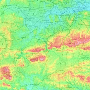
Nombre: Mapa topográfico Surrey, altitud, relieve.
Altitud media: 69 m
Altitud mínima: -1 m
Altitud máxima: 289 m
The highest elevation in Surrey is Leith Hill near Dorking. It is 294 m (965 ft) above sea level and is the second highest point in southeastern England after Walbury Hill in West Berkshire which is 297 m (974 ft) .
Otros mapas topográficos
Haga clic en un mapa para ver su topografía, su altitud y su relieve.
Hungry Hill
United Kingdom > England > Guildford
Hungry Hill, Guildford, Surrey, South East, England, GU23 6NH, United Kingdom
Altitud media: 40 m