
Haz una donación
Mapa topográfico Jerome
Haga clic en el mapa para ver la altitud.
Haz una donación
Jerome
Jerome is about 100 miles (160 km) north of Phoenix and 45 miles (72 km) southwest of Flagstaff along Arizona State Route 89A between Sedona to the east and Prescott to the west. The town is in Arizona's Black Hills, which trend north–south. The town lies within the Prescott National Forest at an elevation of more than 5,000 feet (1,500 m). Woodchute Wilderness is about 3 miles (5 km) west of Jerome, and Mingus Mountain, at 7,726 feet (2,355 m) above sea level, is about 4 miles (6 km) south of town. Jerome State Historic Park is in the town itself. Bitter Creek, a tributary of the Verde River, flows intermittently through Jerome. East of Jerome at the base of the hills are the Verde Valley and the communities of Clarkdale and Cottonwood, site of the nearest airport.
Haz una donación
Acerca de este mapa
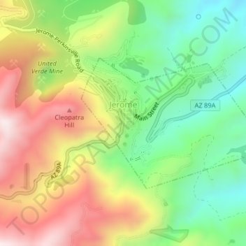
Nombre: Mapa topográfico Jerome, altitud, relieve.
Lugar: Jerome, Yavapai County, Arizona, 86331, United States (34.73958 -112.11939 34.75395 -112.09424)
Altitud media: 1.574 m
Altitud mínima: 1.291 m
Altitud máxima: 1.930 m
Haz una donación
Otros mapas topográficos
Haga clic en un mapa para ver su topografía, su altitud y su relieve.
Haz una donación
Yarnell Hill Fire Memorial Park
United States > Arizona > Yavapai County > Yarnell
Altitud media: 1.498 m
Haz una donación
Cathedral Rock
United States > Arizona > Yavapai County
Cathedral Rock is a natural sandstone butte near Sedona, Arizona, United States, and one of the most-photographed sights in the state. The rock formation is located in Coconino National Forest in Yavapai County, about 1 mile (1.6 km) west of State Route 179 (SR 179), and about 2.5 mi (4.0 km) south of the "Y"…
Altitud media: 1.282 m
Haz una donación
Haz una donación
Haz una donación
Cathedral Rock
United States > Arizona > Yavapai County
Cathedral Rock is a natural sandstone butte near Sedona, Arizona, and one of the most-photographed sights in Arizona, United States. The rock formation is located in the Coconino National Forest in Yavapai County, about 1 mi (1.6 km) west of Arizona Route 179, and about 2.5 mi (4.0 km) south of the "Y"…
Altitud media: 1.282 m
Haz una donación
Haz una donación
Haz una donación
Lynx Lake
United States > Arizona > Yavapai County
Lynx Lake, Arizona, is a 55-acre (220,000 m2) reservoir located within Prescott National Forest, approximately 5 miles (8.0 km) east of Prescott, Arizona, in the Bradshaw Mountains. The lake is located at 5,530 feet (1,690 m) elevation and is stocked for fishing. It is one of the most popular recreation areas…
Altitud media: 1.726 m
Haz una donación
Arcosanti
United States > Arizona > Yavapai County
Arcosanti is a projected experimental town with a molten bronze bell casting business in Yavapai County, central Arizona, United States, 70 mi (110 km) north of Phoenix, at an elevation of 3,732 feet (1,138 m). Its arcology concept was proposed by the Italian-American architect Paolo Soleri (1919–2013). He…
Altitud media: 1.130 m
Haz una donación
Haz una donación