
Mapa topográfico Hillview
Mapa interactivo
Haga clic en el mapa para ver la altitud.
Acerca de este mapa
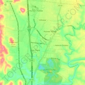
Nombre: Mapa topográfico Hillview, altitud, relieve.
Lugar: Hillview, Bullitt County, Kentucky, United States (38.01750 -85.71003 38.08584 -85.65524)
Altitud media: 162 m
Altitud mínima: 113 m
Altitud máxima: 236 m
Otros mapas topográficos
Haga clic en un mapa para ver su topografía, su altitud y su relieve.
Shepherdsville
United States > Kentucky > Bullitt County
Shepherdsville, Bullitt County, Kentucky, United States
Altitud media: 148 m
Brooks
United States > Kentucky > Bullitt County
Brooks, Bullitt County, Kentucky, 40109, United States
Altitud media: 189 m
Mount Washington
United States > Kentucky > Bullitt County
Mount Washington, Bullitt County, Kentucky, 40047, United States
Altitud media: 184 m
Bernheim Forest
United States > Kentucky > Bullitt County
Bernheim Forest, Bullitt County, Kentucky, United States
Altitud media: 230 m
Salt River
United States > Kentucky > Bullitt County > Shepherdsville
Salt River, Shepherdsville, Bullitt County, Kentucky, 40165, United States
Altitud media: 140 m
Phelps Knob
United States > Kentucky > Bullitt County
Phelps Knob, Bullitt County, Kentucky, 40165, United States
Altitud media: 161 m
Dawson Knob
United States > Kentucky > Bullitt County
Dawson Knob, Bullitt County, Kentucky, United States
Altitud media: 203 m