
Mapa topográfico Auburn
Mapa interactivo
Haga clic en el mapa para ver la altitud.
Acerca de este mapa
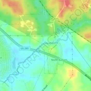
Nombre: Mapa topográfico Auburn, altitud, relieve.
Lugar: Auburn, Lee County, Alabama, United States (32.65790 -85.45920 32.66024 -85.45182)
Altitud media: 203 m
Altitud mínima: 180 m
Altitud máxima: 244 m
The southwest and west regions of the city on the plateau are marked by rolling plains and savannahs, with the undeveloped portion primarily being used for cattle grazing and ranching. South of this region sits the coastal plain, with sandy soil and pine forest. Parts of north Auburn have much more rugged topographies, with thick forests in high hills and deep hollows of the type common to parts of eastern Tennessee. The region surrounded by Chewacla Park in the south of the city contains sharp peaks and sudden drops of elevation as the 1.05 billion-year-old rock of the Appalachians meets the coastal plain.
Otros mapas topográficos
Haga clic en un mapa para ver su topografía, su altitud y su relieve.
Opelika
United States > Alabama > Lee County
Opelika, Lee County, Alabama, 36801, United States
Altitud media: 221 m
Opelika
United States > Alabama > Lee County > Opelika
Opelika, Lee County, Alabama, United States
Altitud media: 239 m
Auburn
United States > Alabama > Lee County > Auburn
Auburn, Lee County, Alabama, 36949, United States
Altitud media: 189 m
Websters Pond
United States > Alabama > Lee County > Auburn
Websters Pond, Auburn Industrial Park, Auburn, Lee County, Alabama, United States
Altitud media: 199 m
Waverly
United States > Alabama > Lee County
Waverly, Lee County, Alabama, 36879, United States
Altitud media: 225 m
Mount Jefferson
United States > Alabama > Lee County > Opelika
Mount Jefferson, Opelika, Lee County, Alabama, United States
Altitud media: 234 m
Oak Dale
United States > Alabama > Lee County > Opelika
Oak Dale, Opelika, Lee County, Alabama, 36801, United States
Altitud media: 238 m
Alta Vista
United States > Alabama > Lee County > Opelika
Alta Vista, Opelika, Lee County, Alabama, 36801, United States
Altitud media: 235 m
Opelika
United States > Alabama > Lee County
Opelika, Lee County, Alabama, United States
Altitud media: 200 m
Beauregard
United States > Alabama > Lee County
Beauregard, Lee County, Alabama, 36804, United States
Altitud media: 187 m
Louise Kreher Forest Ecology Preserve
United States > Alabama > Lee County > Auburn > Farmville
Louise Kreher Forest Ecology Preserve, Farmstone Ridge, Farmville, Auburn, Lee County, Alabama, 36801:36830, United States
Altitud media: 204 m
Auburn
United States > Alabama > Lee County
Auburn, Lee County, Alabama, United States
Altitud media: 200 m
Smiths Station
United States > Alabama > Lee County > Smiths Station
Smiths Station, Lee County, Alabama, 36877, United States
Altitud media: 143 m
Woodfield
United States > Alabama > Lee County > Auburn > Woodfield
Woodfield, Auburn, Lee County, Alabama, 36849, United States
Altitud media: 194 m