
Mapa topográfico Middle Creek
Mapa interactivo
Haga clic en el mapa para ver la altitud.
Acerca de este mapa
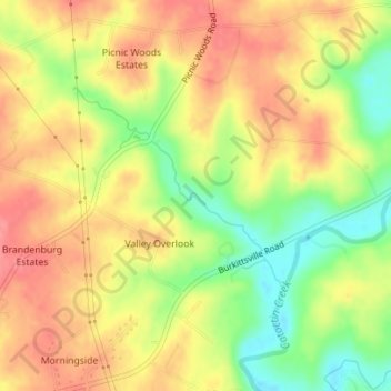
Nombre: Mapa topográfico Middle Creek, altitud, relieve.
Altitud media: 157 m
Altitud mínima: 111 m
Altitud máxima: 192 m
Otros mapas topográficos
Haga clic en un mapa para ver su topografía, su altitud y su relieve.
Queen Anne's County
United States of America > Maryland
Queen Anne's County, Maryland, United States of America
Altitud media: 10 m
Forest Manor
United States of America > Maryland > Forest Manor
Forest Manor, Forestville, Prince George's County, Maryland, 20747, United States of America
Altitud media: 80 m
College Park
United States of America > Maryland > College Park > College Park
College Park, Prince George's County, Maryland, United States of America
Altitud media: 38 m