
Mapa topográfico Bradden
Mapa interactivo
Haga clic en el mapa para ver la altitud.
Acerca de este mapa
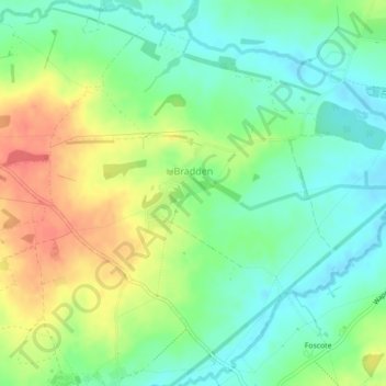
Nombre: Mapa topográfico Bradden, altitud, relieve.
Lugar: Bradden, West Northamptonshire, England, United Kingdom (52.11743 -1.06975 52.14200 -1.02740)
Altitud media: 118 m
Altitud mínima: 95 m
Altitud máxima: 153 m
Otros mapas topográficos
Haga clic en un mapa para ver su topografía, su altitud y su relieve.
Woodford Halse
United Kingdom > England > West Northamptonshire
Woodford Halse, West Northamptonshire, England, NN11 3NS, United Kingdom
Altitud media: 154 m
Chapel Brampton
United Kingdom > England > West Northamptonshire
Chapel Brampton, West Northamptonshire, England, NN6 8AF, United Kingdom
Altitud media: 91 m
Silverstone
United Kingdom > England > West Northamptonshire
Silverstone, West Northamptonshire, England, United Kingdom
Altitud media: 133 m
Astcote
United Kingdom > England > West Northamptonshire
Astcote, Pattishall, West Northamptonshire, England, NN12 8NR, United Kingdom
Altitud media: 129 m
Pury End
United Kingdom > England > West Northamptonshire > Paulerspury
Pury End, Paulerspury, West Northamptonshire, England, NN12 7NX, United Kingdom
Altitud media: 120 m
West Hunsbury
United Kingdom > England > West Northamptonshire
West Hunsbury, West Northamptonshire, England, United Kingdom
Altitud media: 78 m