
Gracias por apoyar a este sitio ❤️
Haz una donación
Haz una donación
Mapa topográfico Waterville
Haga clic en el mapa para ver la altitud.
Gracias por apoyar a este sitio ❤️
Haz una donación
Haz una donación
Acerca de este mapa
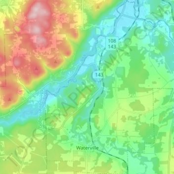
Nombre: Mapa topográfico Waterville, altitud, relieve.
Lugar: Waterville, Coaticook (MRC), Estrie, Quebec, J0B 3H0, Canada (45.26395 -71.92083 45.35087 -71.81586)
Altitud media: 235 m
Altitud mínima: 144 m
Altitud máxima: 432 m
Gracias por apoyar a este sitio ❤️
Haz una donación
Haz una donación
Otros mapas topográficos
Haga clic en un mapa para ver su topografía, su altitud y su relieve.