
Mapa topográfico Tarkastad
Mapa interactivo
Haga clic en el mapa para ver la altitud.
Acerca de este mapa
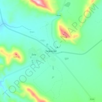
Nombre: Mapa topográfico Tarkastad, altitud, relieve.
Altitud media: 1.347 m
Altitud mínima: 1.228 m
Altitud máxima: 1.777 m
Scientists have stated that Tarkastad has one of the healthiest climates in the world. Winters are cold with frequent snowfalls on high lying mountain tops, while summers are hot and dry. Tarkastad which is situated at an elevation of 1,304 metres normally receives about 335mm of rain per year, with most rainfall occurring mainly during summer.
Otros mapas topográficos
Haga clic en un mapa para ver su topografía, su altitud y su relieve.
Elandskop
South Africa > Eastern Cape > Chris Hani District Municipality > Tsolwana Local Municipality
Elandskop, Tsolwana Local Municipality, Chris Hani District Municipality, Eastern Cape, South Africa
Altitud media: 1.386 m