
Mapa topográfico Ostern
Mapa interactivo
Haga clic en el mapa para ver la altitud.
Acerca de este mapa
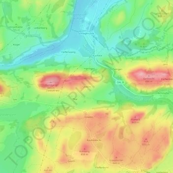
Nombre: Mapa topográfico Ostern, altitud, relieve.
Altitud media: 798 m
Altitud mínima: 735 m
Altitud máxima: 881 m
Otros mapas topográficos
Haga clic en un mapa para ver su topografía, su altitud y su relieve.
Hochplatte
Deutschland > Bayern > Landkreis Ostallgäu > Halblech
Hochplatte, Halblech, Landkreis Ostallgäu, Bayern, Deutschland
Altitud media: 1.646 m
Hirschwang
Deutschland > Bayern > Landkreis Ostallgäu > Halblech
Hirschwang, Halblech, Landkreis Ostallgäu, Bayern, Deutschland
Altitud media: 1.481 m