
Mapa topográfico Columbus
Mapa interactivo
Haga clic en el mapa para ver la altitud.
Columbus
The city lies at an elevation of 1,447 feet (441 m). It is built on the flat terrain of the Platte River valley; rolling hills rise to the north of the city.
Acerca de este mapa
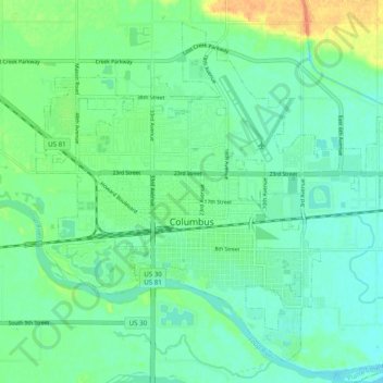
Nombre: Mapa topográfico Columbus, altitud, relieve.
Lugar: Columbus, Platte County, Nebraska, United States (41.40238 -97.39830 41.46771 -97.29998)
Altitud media: 442 m
Altitud mínima: 431 m
Altitud máxima: 469 m
Otros mapas topográficos
Haga clic en un mapa para ver su topografía, su altitud y su relieve.