
Mapa topográfico Kea
Mapa interactivo
Haga clic en el mapa para ver la altitud.
Acerca de este mapa
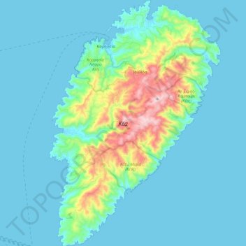
Nombre: Mapa topográfico Kea, altitud, relieve.
Altitud media: 81 m
Altitud mínima: 0 m
Altitud máxima: 565 m
Its capital, Ioulis, is inland at a high altitude (like most ancient Cycladic settlements, for fear of pirates) and is considered quite picturesque. Other major villages of Kea are the port of Korissia and the fishing village of Vourkari. After suffering depopulation for many decades, Kea has been recently rediscovered by Athenians as a convenient destination for weekend and yachting trips. The population in 2019 was 2,568.
Otros mapas topográficos
Haga clic en un mapa para ver su topografía, su altitud y su relieve.
Βουρκάρι
Greece > Aegean > Kea-Kythnos Regional Unit > Korissia
Βουρκάρι, Korissia, Kea Municipality, Kea-Kythnos Regional Unit, South Aegean, Aegean, 840 02, Greece
Altitud media: 63 m