
Mapa topográfico Garstang
Mapa interactivo
Haga clic en el mapa para ver la altitud.
Acerca de este mapa
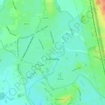
Nombre: Mapa topográfico Garstang, altitud, relieve.
Lugar: Garstang, Borough of Wyre, Lancashire, England, United Kingdom (53.89262 -2.79394 53.91382 -2.76443)
Altitud media: 24 m
Altitud mínima: 10 m
Altitud máxima: 59 m
Otros mapas topográficos
Haga clic en un mapa para ver su topografía, su altitud y su relieve.
Inskip
United Kingdom > England > Lancashire > Borough of Wyre
Inskip, Borough of Wyre, Lancashire, England, PR4 0SL, United Kingdom
Altitud media: 14 m
Forton
United Kingdom > England > Lancashire > Borough of Wyre
Forton, Borough of Wyre, Lancashire, England, PR3 0BG, United Kingdom
Altitud media: 30 m