
Mapa topográfico Stanford
Mapa interactivo
Haga clic en el mapa para ver la altitud.
Acerca de este mapa
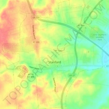
Nombre: Mapa topográfico Stanford, altitud, relieve.
Lugar: Stanford, Lincoln County, Kentucky, United States (37.51584 -84.68342 37.55135 -84.64032)
Altitud media: 292 m
Altitud mínima: 258 m
Altitud máxima: 319 m
Otros mapas topográficos
Haga clic en un mapa para ver su topografía, su altitud y su relieve.
Hustonville
United States > Kentucky > Lincoln County
Hustonville, Lincoln County, Kentucky, United States
Altitud media: 316 m
Kings Mountain
United States > Kentucky > Lincoln County
Kings Mountain, Lincoln County, Kentucky, 40442, United States
Altitud media: 375 m
Blue Lick
United States > Kentucky > Lincoln County
Blue Lick, Lincoln County, Kentucky, 40484, United States
Altitud media: 336 m
logan hubble park
United States > Kentucky > Lincoln County
logan hubble park, Lincoln County, Kentucky, United States
Altitud media: 267 m
Crab Orchard
United States > Kentucky > Lincoln County
Crab Orchard, Lincoln County, Kentucky, United States
Altitud media: 283 m