
Mapa topográfico Coldwater
Mapa interactivo
Haga clic en el mapa para ver la altitud.
Acerca de este mapa
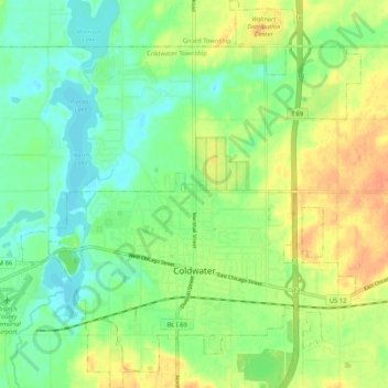
Nombre: Mapa topográfico Coldwater, altitud, relieve.
Lugar: Coldwater, Branch County, Michigan, United States of America (41.91658 -85.04757 41.99473 -84.95543)
Altitud media: 296 m
Altitud mínima: 279 m
Altitud máxima: 318 m
Coldwater is at 41°56′25″N 85°00′02″W / 41.94028°N 85.00056°W / 41.94028; -85.00056. The ZIP code is 49036 and the FIPS place code is 17020. The elevation is 969 feet (295 m) above sea level. The City of Coldwater is entirely surrounded by the Township of Coldwater.