
Mapa topográfico Gloucester
Mapa interactivo
Haga clic en el mapa para ver la altitud.
Acerca de este mapa
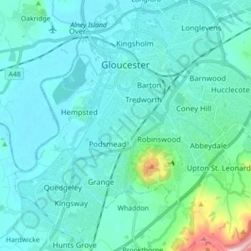
Nombre: Mapa topográfico Gloucester, altitud, relieve.
Lugar: Gloucester, Gloucestershire, England, United Kingdom (51.80757 -2.30139 51.88522 -2.17726)
Altitud media: 36 m
Altitud mínima: 4 m
Altitud máxima: 274 m
Otros mapas topográficos
Haga clic en un mapa para ver su topografía, su altitud y su relieve.
Painswick
United Kingdom > England > Gloucestershire
Painswick, Stroud, Gloucestershire, England, United Kingdom
Altitud media: 163 m
Cheltenham
United Kingdom > England > Gloucestershire
Cheltenham, Gloucestershire, England, United Kingdom
Altitud media: 109 m
Cirencester
United Kingdom > England > Gloucestershire > Cotswold District > Chesterton
Cirencester, Chesterton, Cotswold District, Gloucestershire, England, United Kingdom
Altitud media: 128 m