
Mapa topográfico Round Rock
Mapa interactivo
Haga clic en el mapa para ver la altitud.
Round Rock
The city straddles the Balcones Escarpment, a fault line in which the areas roughly east of Interstate 35 are flat and characterized by having black, fertile soils of the Blackland Prairie, and the west side of the Escarpment, which consists mostly of hilly, karst-like terrain with little topsoil and higher elevations and which is part of the Texas Hill Country. Located about 20 miles (32 km) north of downtown Austin, Round Rock shares a common border with Austin at Texas State Highway 45.
Acerca de este mapa
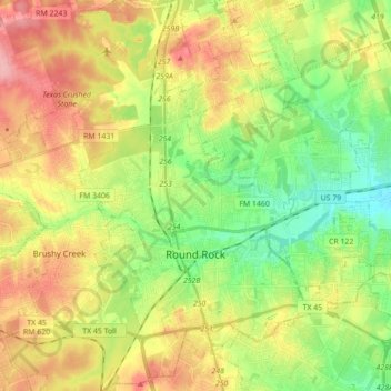
Nombre: Mapa topográfico Round Rock, altitud, relieve.
Lugar: Round Rock, Williamson County, Texas, United States (30.46829 -97.76484 30.59378 -97.59005)
Altitud media: 242 m
Altitud mínima: 191 m
Altitud máxima: 306 m
Otros mapas topográficos
Haga clic en un mapa para ver su topografía, su altitud y su relieve.
Soil Conservation Service Site 12 Dam
United States > Texas > Williamson County > Type
Altitud media: 173 m