
Mapa topográfico Streetsboro
Mapa interactivo
Haga clic en el mapa para ver la altitud.
Acerca de este mapa
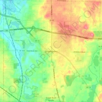
Nombre: Mapa topográfico Streetsboro, altitud, relieve.
Lugar: Streetsboro, Portage County, Ohio, 44241, United States (41.20234 -81.39213 41.27661 -81.29852)
Altitud media: 335 m
Altitud mínima: 300 m
Altitud máxima: 379 m
Otros mapas topográficos
Haga clic en un mapa para ver su topografía, su altitud y su relieve.
Windham Township
United States > Ohio > Portage County
Windham Township, Portage County, Ohio, United States
Altitud media: 315 m
Randolph Township
United States > Ohio > Portage County
Randolph Township, Portage County, Ohio, 44265, United States
Altitud media: 353 m
Aurora
United States > Ohio > Portage County
Aurora, Portage County, Ohio, 44202, United States
Altitud media: 335 m
Kent
United States > Ohio > Portage County > Kent > Kent
Kent, Portage County, Ohio, 44240, United States
Altitud media: 329 m
Atwater
United States > Ohio > Portage County > Atwater
Atwater, Atwater Township, Portage County, Ohio, United States
Altitud media: 346 m
Kent
United States > Ohio > Portage County
Kent, Portage County, Ohio, United States
Altitud media: 328 m