Geolocalizar

Mapa topográfico 85049

Mapa interactivo

Haga clic en el mapa para ver la altitud.

Acerca de este mapa

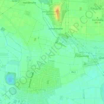
Nombre: Mapa topográfico 85049, altitud, relieve.

Lugar: 85049, West, Ingolstadt, Bayern, Deutschland (48.76375 11.35338 48.76385 11.35348)

Altitud media: 377 m

Altitud mínima: 365 m

Altitud máxima: 397 m

Otros mapas topográficos

Haga clic en un mapa para ver su topografía, su altitud y su relieve.

Dünzlau

Deutschland > Bayern > Ingolstadt > Dünzlauer Mühle

Dünzlau, Dünzlauer Mühle, West, Ingolstadt, Bayern, 85049, Deutschland

Altitud media: 378 m

Niederfeld

Deutschland > Bayern > Ingolstadt

Niederfeld, Südost, Ingolstadt, Bayern, Deutschland

Altitud media: 365 m

Unterbrunnenreuth

Deutschland > Bayern > Ingolstadt

Unterbrunnenreuth, Süd, Ingolstadt, Bayern, Deutschland

Altitud media: 369 m

Irgertsheim

Deutschland > Bayern > Ingolstadt

Irgertsheim, West, Ingolstadt, Bayern, Deutschland

Altitud media: 385 m

Zuchering

Deutschland > Bayern > Ingolstadt > Zuchering

Zuchering, Ingolstadt, Bayern, 85051, Deutschland

Altitud media: 370 m

Gerolfing Nord

Deutschland > Bayern > Ingolstadt > Gerolfing Nord

Gerolfing Nord, West, Ingolstadt, Bayern, 85049, Deutschland

Altitud media: 374 m

Richard-Strauss-Straße

Deutschland > Bayern > Ingolstadt

Richard-Strauss-Straße, Nordwest, Ingolstadt, Bayern, Deutschland

Altitud media: 377 m