
Mapa topográfico Manorville
Mapa interactivo
Haga clic en el mapa para ver la altitud.
Acerca de este mapa
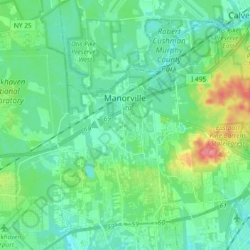
Nombre: Mapa topográfico Manorville, altitud, relieve.
Altitud media: 22 m
Altitud mínima: 4 m
Altitud máxima: 80 m
Manorville is in the center of Long Island with no access to the water. It lies partially on the Ronkonkoma terminal moraine, which creates some slightly rolling topography, especially in the central portion of the hamlet. The glacial topography of the area features several kettle hole ponds, the most well-known of which is Punk's Hole, where a Revolutionary War captain was rumored to have hid from the British.
Otros mapas topográficos
Haga clic en un mapa para ver su topografía, su altitud y su relieve.
Town of Brookhaven
United States > New York > Suffolk County > Town of Brookhaven
Town of Brookhaven, Suffolk County, New York, United States
Altitud media: 10 m
Medford
United States > New York > Suffolk County > Town of Brookhaven
Medford, Town of Brookhaven, Suffolk County, New York, 11763, United States
Altitud media: 35 m
East Moriches
United States > New York > Suffolk County > Town of Brookhaven > East Moriches
East Moriches, Town of Brookhaven, Suffolk County, New York, 11940, United States
Altitud media: 9 m