
Mapa topográfico Port Angeles
Mapa interactivo
Haga clic en el mapa para ver la altitud.
Acerca de este mapa
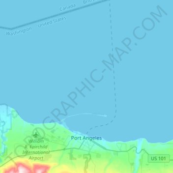
Nombre: Mapa topográfico Port Angeles, altitud, relieve.
Altitud media: 27 m
Altitud mínima: -6 m
Altitud máxima: 501 m
Otros mapas topográficos
Haga clic en un mapa para ver su topografía, su altitud y su relieve.
Sequim
United States > Washington > Clallam County
Sequim, Clallam County, Washington, United States
Altitud media: 88 m
Lake Crescent
United States > Washington > Clallam County
Lake Crescent, Clallam County, Washington, United States
Altitud media: 564 m
Solmar Lake Dam
United States > Washington > Clallam County
Solmar Lake Dam, Clallam County, Washington, United States
Altitud media: 80 m
Clallam Bay
United States > Washington > Clallam County
Clallam Bay, Clallam County, Washington, United States
Altitud media: 39 m
Sunrise View Point
United States > Washington > Clallam County
Sunrise View Point, Hurricane Ridge to Switchback Trail, Clallam County, Washington, United States
Altitud media: 1.397 m
Lake Crescent
United States > Washington > Clallam County
Lake Crescent, Clallam County, Washington, United States
Altitud media: 564 m