
Mapa topográfico Sigri
Mapa interactivo
Haga clic en el mapa para ver la altitud.
Acerca de este mapa
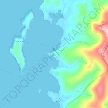
Nombre: Mapa topográfico Sigri, altitud, relieve.
Altitud media: 44 m
Altitud mínima: 0 m
Altitud máxima: 256 m
Otros mapas topográficos
Haga clic en un mapa para ver su topografía, su altitud y su relieve.
Taxiarches
Greece > Aegean > Lesbos Regional Unit > Mytilene Municipal Unit
Taxiarches, Mytilene Municipal Unit, Municipality of Mytilene, Lesbos Regional Unit, Northern Aegean, Aegean, 811 00, Greece
Altitud media: 149 m
Mytilene Municipal Unit
Greece > Aegean > Lesbos Regional Unit
Mytilene Municipal Unit, Municipality of Mytilene, Lesbos Regional Unit, Northern Aegean, Aegean, Greece
Altitud media: 67 m
Vareia
Greece > Aegean > Lesbos Regional Unit > Mytilene Municipal Unit
Vareia, Mytilene Municipal Unit, Municipality of Mytilene, Lesbos Regional Unit, Northern Aegean, Aegean, 811 00, Greece
Altitud media: 66 m
Mytilene
Greece > Aegean > Lesbos Regional Unit
Mytilene, Mytilene Municipal Unit, Municipality of Mytilene, Lesbos Regional Unit, Northern Aegean, Aegean, 811 00, Greece
Altitud media: 80 m
Λέσβος
Greece > Aegean > Lesbos Regional Unit
Λέσβος, Municipality of Western Lesvos, Lesbos Regional Unit, Northern Aegean, Aegean, Greece
Altitud media: 74 m