
Haz una donación
Mapa topográfico Ray Mountain
Haga clic en el mapa para ver la altitud.
Haz una donación
Acerca de este mapa
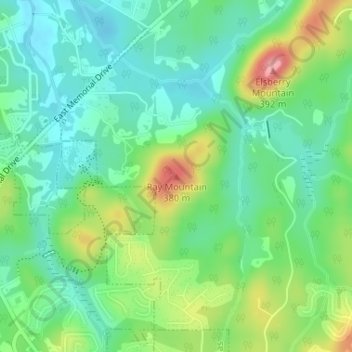
Nombre: Mapa topográfico Ray Mountain, altitud, relieve.
Lugar: Ray Mountain, Paulding County, Georgia, 30132, United States (33.92978 -84.81388 33.92988 -84.81378)
Altitud media: 306 m
Altitud mínima: 267 m
Altitud máxima: 386 m
Haz una donación
Otros mapas topográficos
Haga clic en un mapa para ver su topografía, su altitud y su relieve.
Dallas
United States > Georgia > Paulding County
On April 4, 1977, near the site marker for the Battle of New Hope Church, the forced landing of Southern Airways Flight 242 occurred. The passenger jetliner, a McDonnell Douglas DC-9 with 81 passengers and 4 crew members, was flying from Northwest Alabama Regional Airport to Atlanta Municipal Airport. Upon…
Altitud media: 307 m
Haz una donación
Dallas
United States > Georgia > Paulding County
On April 4, 1977, near the site marker for the Battle of New Hope Church, the forced landing of Southern Airways Flight 242 occurred. The passenger jetliner, a McDonnell Douglas DC-9 with 81 passengers and 4 crew members, was flying from Northwest Alabama Regional Airport to Atlanta Municipal Airport. Upon…
Altitud media: 307 m