
Mapa topográfico Δημοτική Ενότητα Δερβενοχωρίων
Mapa interactivo
Haga clic en el mapa para ver la altitud.
Acerca de este mapa
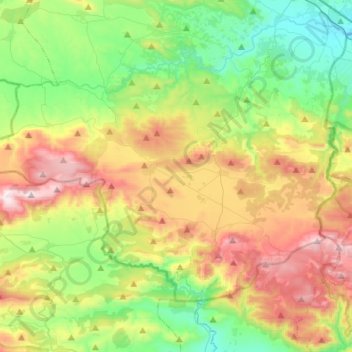
Nombre: Mapa topográfico Δημοτική Ενότητα Δερβενοχωρίων, altitud, relieve.
Altitud media: 417 m
Altitud mínima: 62 m
Altitud máxima: 1.011 m
Otros mapas topográficos
Haga clic en un mapa para ver su topografía, su altitud y su relieve.
Levadia Municipal Unit
Greece > Thessaly and Central Greece > Regional Unit of Boeotia
Levadia Municipal Unit, Municipality of Livadia, Regional Unit of Boeotia, Central Greece, Thessaly and Central Greece, Greece
Altitud media: 468 m
Livadia
Greece > Thessaly and Central Greece > Regional Unit of Boeotia > Levadia Municipal Unit
Livadia, Levadia Municipal Unit, Municipality of Livadia, Regional Unit of Boeotia, Central Greece, Thessaly and Central Greece, 321 00, Greece
Altitud media: 313 m
Pyli
Greece > Thessaly and Central Greece > Regional Unit of Boeotia > Δημοτική Ενότητα Δερβενοχωρίων
Pyli, Δημοτική Ενότητα Δερβενοχωρίων, Municipality of Tanagra, Regional Unit of Boeotia, Central Greece, Thessaly and Central Greece, 190 12, Greece
Altitud media: 574 m
Cheronia
Greece > Thessaly and Central Greece > Regional Unit of Boeotia > Cheronia
Cheronia, Χαιρώνεια - Ακόντιο, Κοινότητα Χαιρώνειας, Cheronia, Municipality of Livadia, Regional Unit of Boeotia, Central Greece, Thessaly and Central Greece, 321 00, Greece
Altitud media: 147 m
Arachova
Greece > Thessaly and Central Greece > Regional Unit of Boeotia > Δημοτική Ενότητα Αραχώβης > Arachova
Arachova, Δημοτική Ενότητα Αραχώβης, Distomo-Arachova-Antikyra Municipality, Regional Unit of Boeotia, Central Greece, Thessaly and Central Greece, 32004, Greece
Altitud media: 901 m
Tanagra
Greece > Thessaly and Central Greece > Regional Unit of Boeotia > Δημοτική Ενότητα Τανάγρας > Tanagra
Tanagra, Δημοτική Ενότητα Τανάγρας, Municipality of Tanagra, Regional Unit of Boeotia, Central Greece, Thessaly and Central Greece, 32009, Greece
Altitud media: 231 m