
Mapa topográfico Bellepoint
Mapa interactivo
Haga clic en el mapa para ver la altitud.
Acerca de este mapa
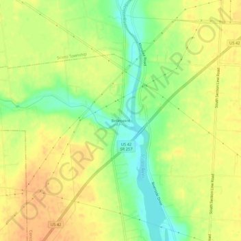
Nombre: Mapa topográfico Bellepoint, altitud, relieve.
Altitud media: 279 m
Altitud mínima: 257 m
Altitud máxima: 294 m
Otros mapas topográficos
Haga clic en un mapa para ver su topografía, su altitud y su relieve.
Lewis Center
United States > Ohio > Delaware County
Lewis Center, Orange Township, Delaware County, Ohio, 43035, United States
Altitud media: 286 m
Africa
United States > Ohio > Delaware County
Africa, Orange Township, Delaware County, Ohio, 43035, United States
Altitud media: 274 m
Powell
United States > Ohio > Delaware County
Powell, Liberty Township, Delaware County, Ohio, United States
Altitud media: 274 m