
Mapa topográfico Yongsan-gu
Mapa interactivo
Haga clic en el mapa para ver la altitud.
Acerca de este mapa
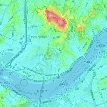
Nombre: Mapa topográfico Yongsan-gu, altitud, relieve.
Lugar: Yongsan-gu, Seoul, South Korea (37.50647 126.94458 37.55564 127.01752)
Altitud media: 39 m
Altitud mínima: 2 m
Altitud máxima: 265 m
Yongsan is located next to the Han River, with level ground in the west of the district which has been used for transportation (rail) and commercial use since the early 20th century. To the east and north in the land is steeper and rises towards Namsan which lies to the north. Namsan has an elevation of 243m and consists mostly of granite. The low lying western section of the district is approximately 15-20 above sea level. This low-lying area has been prone to flooding during periods of heavy rainfall, a common issue with most of the low lying riverside districts in the city.
Otros mapas topográficos
Haga clic en un mapa para ver su topografía, su altitud y su relieve.
Pyeongchang-dong
Pyeongchang-dong, Jongno-gu, Seoul, South Korea
Altitud media: 268 m
Bangbae-dong
South Korea > Seoul > Seocho-gu > Bangbae-dong
Bangbae-dong, Seocho-gu, Seoul, South Korea
Altitud media: 79 m
Samseong-dong
South Korea > Seoul > Gangnam-gu > Samseong-dong
Samseong-dong, Gangnam-gu, Seoul, South Korea
Altitud media: 35 m
Mangu-dong
South Korea > Seoul > Mangu-dong
Mangu-dong, Jungnang-gu, Seoul, Nowon-gu, South Korea
Altitud media: 75 m
Ssangmun-dong
South Korea > Seoul > Ssangmun-dong
Ssangmun-dong, Dobong-gu, Seoul, Nowon-gu, South Korea
Altitud media: 49 m
Seoul
South Korea > Seoul > Songpa-gu
Jamsil 7(chil)-dong, Songpa-gu, Seoul, 05571, South Korea
Altitud media: 22 m
Seoul
South Korea > Seoul > Eunpyeong-gu
Gusan-dong, Eunpyeong-gu, Seoul, South Korea
Altitud media: 52 m
Seoul
South Korea > Seoul > Eunpyeong-gu
Nokbeon-dong, Eunpyeong-gu, Seoul, South Korea
Altitud media: 77 m
Euljiro 7-ga
South Korea > Seoul > Jung-gu > Euljiro 7-ga
Euljiro 7-ga, Jung-gu, Seoul, 04566, South Korea
Altitud media: 55 m