
Mapa topográfico Olaton
Mapa interactivo
Haga clic en el mapa para ver la altitud.
Acerca de este mapa
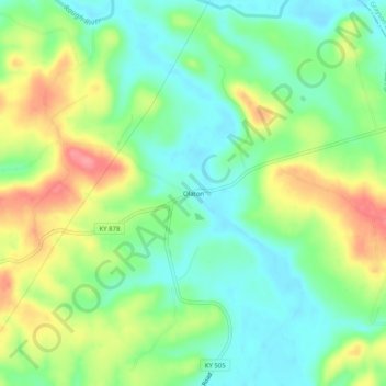
Nombre: Mapa topográfico Olaton, altitud, relieve.
Lugar: Olaton, Ohio County, Kentucky, 42361, United States (37.50588 -86.70749 37.54588 -86.66749)
Altitud media: 157 m
Altitud mínima: 123 m
Altitud máxima: 210 m
Otros mapas topográficos
Haga clic en un mapa para ver su topografía, su altitud y su relieve.
Hartford
United States > Kentucky > Ohio County
Hartford, Ohio County, Kentucky, United States
Altitud media: 123 m
No Creek
United States > Kentucky > Ohio County
No Creek, Ohio County, Kentucky, United States
Altitud media: 129 m
Fordsville
United States > Kentucky > Ohio County > Fordsville
Fordsville, Ohio County, Kentucky, United States
Altitud media: 163 m