
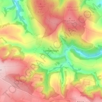
Mapa topográfico Luxborough
Mapa interactivo
Haga clic en el mapa para ver la altitud.
Acerca de este mapa
Nombre: Mapa topográfico Luxborough, altitud, relieve.
Altitud media: 292 m
Altitud mínima: 135 m
Altitud máxima: 418 m
Otros mapas topográficos
Haga clic en un mapa para ver su topografía, su altitud y su relieve.
Minehead
United Kingdom > England > Somerset > Somerset West and Taunton
Minehead, Somerset West and Taunton, Somerset, England, United Kingdom
Altitud media: 86 m
Allerford
United Kingdom > England > Somerset > Somerset West and Taunton > Allerford
Allerford, Somerset West and Taunton, Somerset, England, TA24 8HN, United Kingdom
Altitud media: 112 m
Porlock
United Kingdom > England > Somerset > Somerset West and Taunton > Porlock
Porlock, Somerset West and Taunton, Somerset, England, United Kingdom
Altitud media: 207 m
Bossington
United Kingdom > England > Somerset > Somerset West and Taunton > Bossington
Bossington, Somerset West and Taunton, Somerset, England, TA24 8HQ, United Kingdom
Altitud media: 69 m
Horner Water
United Kingdom > England > Somerset > Somerset West and Taunton > Luccombe
Horner Water, Luccombe, Somerset West and Taunton, Somerset, England, TA24 8HY, United Kingdom
Altitud media: 248 m
Halse Combe
United Kingdom > England > Somerset > Somerset West and Taunton > Allerford > Horner
Halse Combe, Horner, Luccombe, Allerford, Somerset West and Taunton, Somerset, England, TA24 8HX, United Kingdom
Altitud media: 134 m
Watchet
United Kingdom > England > Somerset > Somerset West and Taunton
Watchet, Somerset West and Taunton, Somerset, England, United Kingdom
Altitud media: 20 m
Taunton
United Kingdom > England > Somerset > Somerset West and Taunton
Taunton, Somerset West and Taunton, Somerset, England, TA1 1JD, United Kingdom
Altitud media: 39 m