
Mapa topográfico Charleston County
Mapa interactivo
Haga clic en el mapa para ver la altitud.
Acerca de este mapa
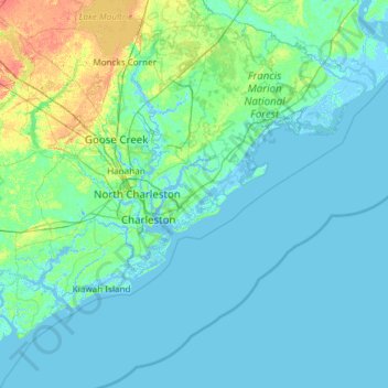
Nombre: Mapa topográfico Charleston County, altitud, relieve.
Lugar: Charleston County, South Carolina, United States of America (32.49280 -80.45191 33.21502 -79.25611)
Altitud media: 5 m
Altitud mínima: -4 m
Altitud máxima: 40 m
Otros mapas topográficos
Haga clic en un mapa para ver su topografía, su altitud y su relieve.
Newberry County
United States of America > South Carolina
Newberry County, South Carolina, United States of America
Altitud media: 136 m
Travelers Rest
United States of America > South Carolina > Travelers Rest
Travelers Rest, Greenville County, South Carolina, United States of America
Altitud media: 338 m
Georgetown County
United States of America > South Carolina
Georgetown County, South Carolina, United States of America
Altitud media: 6 m