
Mapa topográfico A la Reine Des Belges
Mapa interactivo
Haga clic en el mapa para ver la altitud.
Acerca de este mapa
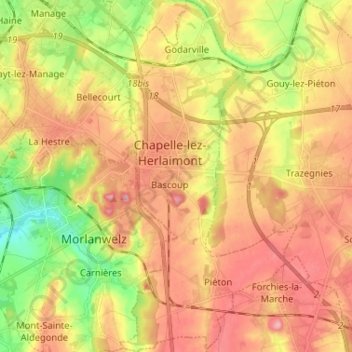
Nombre: Mapa topográfico A la Reine Des Belges, altitud, relieve.
Altitud media: 150 m
Altitud mínima: 82 m
Altitud máxima: 204 m
Otros mapas topográficos
Haga clic en un mapa para ver su topografía, su altitud y su relieve.
Le Piéton
Belgique > Wallonie > Chapelle-lez-Herlaimont
Le Piéton, Chapelle-lez-Herlaimont, Charleroi, Hainaut, Wallonie, 7160, Belgique
Altitud media: 173 m