
Mapa topográfico Village of Walden
Mapa interactivo
Haga clic en el mapa para ver la altitud.
Acerca de este mapa
Nombre: Mapa topográfico Village of Walden, altitud, relieve.
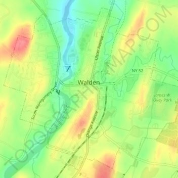
Altitud media: 114 m
Altitud mínima: 80 m
Altitud máxima: 149 m
The Wallkill passes through a small gorge between the two dams and loses approximately 60 feet (18 m) of elevation in the process. The surrounding topography in the village is, correspondingly, gentle rolling hills of this section of the Great Appalachian Valley between the higher rises of the Shawangunk Ridge, visible to the west from some sections of the village, and the Hudson Highlands to the southwest. The highest elevation is roughly 520 feet (158 m) above sea level along Overlook Road at the village's western boundary; the lowest is 260 feet (79 m) along the Wallkill at the northern village line.