
Mapa topográfico Harpers Ferry
Mapa interactivo
Haga clic en el mapa para ver la altitud.
Acerca de este mapa
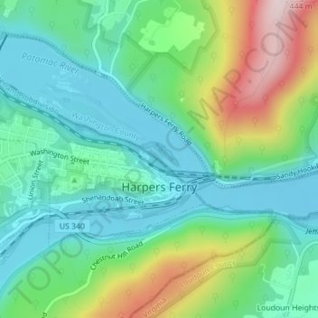
Nombre: Mapa topográfico Harpers Ferry, altitud, relieve.
Altitud media: 174 m
Altitud mínima: 71 m
Altitud máxima: 421 m
The town was "easy to seize, and hard to hold", because of its topography: surrounded on three sides by high ground – Bolivar Heights to the west, Loudoun Heights to the south, and Maryland Heights to the east – and surrounded by the Potomac and Shenandoah Rivers, anyone who controlled the heights controlled the city.