
Haz una donación
Mapa topográfico Lost Bridge Village
Haga clic en el mapa para ver la altitud.
Haz una donación
Acerca de este mapa
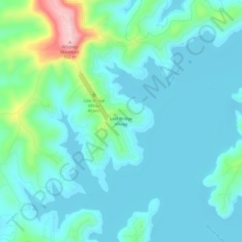
Nombre: Mapa topográfico Lost Bridge Village, altitud, relieve.
Lugar: Lost Bridge Village, Benton County, Arkansas, United States (36.36841 -93.92686 36.40841 -93.88686)
Altitud media: 377 m
Altitud mínima: 339 m
Altitud máxima: 551 m
Haz una donación
Otros mapas topográficos
Haga clic en un mapa para ver su topografía, su altitud y su relieve.
Haz una donación
Haz una donación
Beaver Lake
United States > Arkansas > Benton County > Goshen
Beaver Dam was authorized by the Flood Control Act of 1944 and other following acts. The United States Army Corps of Engineers constructed Beaver Dam during the years 1960-1966, impounding a major part of the White River and creating Beaver Lake and flooding much of the valley including the remains of the…
Altitud media: 392 m
Benton Country Fair Grounds
United States > Arkansas > Benton County > Bentonville
Altitud media: 384 m
Haz una donación
Haz una donación