
Mapa topográfico Berdan
Mapa interactivo
Haga clic en el mapa para ver la altitud.
Acerca de este mapa
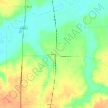
Nombre: Mapa topográfico Berdan, altitud, relieve.
Lugar: Berdan, Greene County, Illinois, United States (39.34505 -90.41540 39.38505 -90.37540)
Altitud media: 153 m
Altitud mínima: 135 m
Altitud máxima: 174 m
Otros mapas topográficos
Haga clic en un mapa para ver su topografía, su altitud y su relieve.
Hillview
United States > Illinois > Greene County > Hillview
Hillview, Greene County, Illinois, 62050, United States
Altitud media: 157 m
White Hall
United States > Illinois > Greene County
White Hall, Greene County, Illinois, 62092, United States
Altitud media: 176 m