
Mapa topográfico Ridgecrest
Mapa interactivo
Haga clic en el mapa para ver la altitud.
Acerca de este mapa
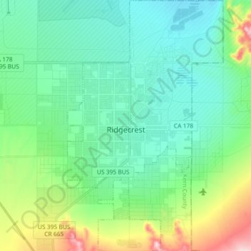
Nombre: Mapa topográfico Ridgecrest, altitud, relieve.
Lugar: Ridgecrest, Kern County, California, United States (35.56389 -117.70589 35.68079 -117.61640)
Altitud media: 740 m
Altitud mínima: 667 m
Altitud máxima: 1.022 m
Walker Pass (elevation 5,250 ft (1.60 km)) is a mountain pass by Lake Isabella in the southern Sierra Nevada mountains. It is located in northeastern Kern County, approximately 53 mi (85 km) ENE of Bakersfield and 10 mi (16 km) WSW of Ridgecrest. The pass provides a route between the San Joaquin Valley on the west and the Mojave Desert on the east.