
Mapa topográfico Loiu
Mapa interactivo
Haga clic en el mapa para ver la altitud.
Acerca de este mapa
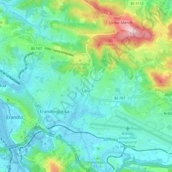
Nombre: Mapa topográfico Loiu, altitud, relieve.
Altitud media: 70 m
Altitud mínima: 0 m
Altitud máxima: 293 m
Otros mapas topográficos
Haga clic en un mapa para ver su topografía, su altitud y su relieve.
Getxo
Spain > Autonomous Community of the Basque Country > Andraka
Getxo, Andraka, Biscay, Autonomous Community of the Basque Country, 48620, Spain
Altitud media: 36 m
Mungia
Spain > Autonomous Community of the Basque Country > Andraka
Mungia, Andraka, Biscay, Autonomous Community of the Basque Country, 48620, Spain
Altitud media: 111 m
Plentzia
Spain > Autonomous Community of the Basque Country > Andraka
Plentzia, Andraka, Biscay, Autonomous Community of the Basque Country, 48620, Spain
Altitud media: 61 m
Urduliz
Spain > Autonomous Community of the Basque Country > Andraka
Urduliz, Andraka, Biscay, Autonomous Community of the Basque Country, 48620, Spain
Altitud media: 90 m