
Mapa topográfico Warlingham
Mapa interactivo
Haga clic en el mapa para ver la altitud.
Acerca de este mapa
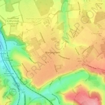
Nombre: Mapa topográfico Warlingham, altitud, relieve.
Altitud media: 163 m
Altitud mínima: 90 m
Altitud máxima: 224 m
Elevations vary from 110m AOD at Woldingham Road, at the southernmost point of the parish, with a gentle increase in height through the village along the main road heading to the southeast, to the highest elevation (199.6m) at Limpsfield Road.
Otros mapas topográficos
Haga clic en un mapa para ver su topografía, su altitud y su relieve.
Tandridge District
United Kingdom > England > Surrey > Tandridge District
Tandridge District, Surrey, South East England, England, United Kingdom
Altitud media: 114 m
Nutfield
United Kingdom > England > Surrey > Tandridge District
Nutfield, Tandridge District, Surrey, England, United Kingdom
Altitud media: 88 m
Caterham
United Kingdom > England > Surrey > Tandridge District
Caterham, Tandridge District, Surrey, England, CR3 6XS, United Kingdom
Altitud media: 157 m