
Gracias por apoyar a este sitio ❤️
Haz una donación
Haz una donación
Mapa topográfico Hiawassee
Haga clic en el mapa para ver la altitud.
Gracias por apoyar a este sitio ❤️
Haz una donación
Haz una donación
Acerca de este mapa
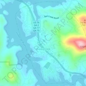
Nombre: Mapa topográfico Hiawassee, altitud, relieve.
Lugar: Hiawassee, Towns County, Georgia, United States (34.93665 -83.76999 34.96129 -83.73910)
Altitud media: 634 m
Altitud mínima: 581 m
Altitud máxima: 859 m
Gracias por apoyar a este sitio ❤️
Haz una donación
Haz una donación
Otros mapas topográficos
Haga clic en un mapa para ver su topografía, su altitud y su relieve.