
Mapa topográfico Laganas
Mapa interactivo
Haga clic en el mapa para ver la altitud.
Laganas
Laganas (Greek: Λαγανάς) is a village and a former municipality on the island of Zakynthos, Ionian Islands, Greece. Since the 2011 local government reform it is part of the municipality Zakynthos, of which it is a municipal unit. The municipal unit Laganas covers the southernmost part of Zakynthos. Its municipal seat was the town of Pantokratoras (pop. 925 in 2011). The municipal unit of Laganas has a land area of 74.104 km². Its largest towns are Mouzaki (pop. 1,702), Lithakia (pop. 1,307), Pantokratoras, Kalamaki (pop. 890), Laganas (pop. 729), and Keri (pop. 469). The central and eastern part of the municipal unit are flat, but there are hills up to 450 m elevation in the west. The Zakynthos International Airport lies in the eastern part of the municipal unit, near Kalamaki. The beach village Laganas, part of the community of Pantokratoras, is on the southeastern coast. A large part of Laganas is a national park, established for the protection of turtles.
Acerca de este mapa
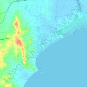
Nombre: Mapa topográfico Laganas, altitud, relieve.
Altitud media: 8 m
Altitud mínima: -3 m
Altitud máxima: 59 m