
Mapa topográfico Summit County
Mapa interactivo
Haga clic en el mapa para ver la altitud.
Acerca de este mapa
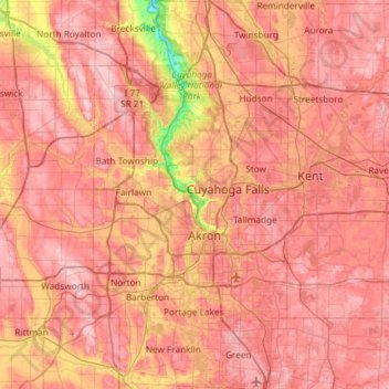
Nombre: Mapa topográfico Summit County, altitud, relieve.
Lugar: Summit County, Ohio, United States of America (40.90650 -81.68849 41.35113 -81.39169)
Altitud media: 327 m
Altitud mínima: 187 m
Altitud máxima: 405 m
Summit County is an urban county in the U.S. state of Ohio. As of the 2010 census, the population was 541,781 making it the fourth-most populous county in Ohio. Its county seat is Akron. The county was formed on March 3, 1840, from portions of Medina, Portage and Stark Counties. It was named "Summit County" because the highest elevation on the Ohio and Erie Canal is located in the county.
Otros mapas topográficos
Haga clic en un mapa para ver su topografía, su altitud y su relieve.
Allen County
United States of America > Ohio
Allen County, Ohio, United States of America
Altitud media: 264 m
Kimbolton
United States of America > Ohio > Kimbolton
Kimbolton, Guernsey County, Ohio, 43749, United States of America
Altitud media: 275 m
Highland County
United States of America > Ohio
Highland County, Ohio, United States of America
Altitud media: 305 m
Ottawa County
United States of America > Ohio
Ottawa County, Ohio, United States of America
Altitud media: 180 m