
Mapa topográfico Signal de Botrange
Mapa interactivo
Haga clic en el mapa para ver la altitud.
Acerca de este mapa
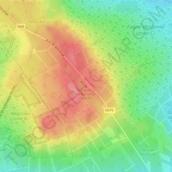
Nombre: Mapa topográfico Signal de Botrange, altitud, relieve.
Altitud media: 658 m
Altitud mínima: 616 m
Altitud máxima: 701 m
In 1923, the 6-metre (20-foot) Baltia tower was built on the summit to allow visitors to reach an altitude of 700 m (2,300 ft). A stone tower built in 1933/34 by François Fagnoul from Ovifat on the Botrange crowned a steel weather vane with the relieved name SICCO CAMPO until World War II. Meanwhile, the spire serves as transmitter of Radio Contact and reaches a de facto height of 718 m (2,356 ft).
Otros mapas topográficos
Haga clic en un mapa para ver su topografía, su altitud y su relieve.
Ardennes
Belgium > Liège > Verviers > Robertville
Ardennes, Robertville, Waimes, Verviers, Liège, Wallonia, Belgium
Altitud media: 659 m
Ovifat
Belgium > Liège > Verviers > Robertville
Ovifat, Robertville, Waimes, Verviers, Liège, Wallonia, Belgium
Altitud media: 591 m