
Mapa topográfico Miller Township
Mapa interactivo
Haga clic en el mapa para ver la altitud.
Acerca de este mapa
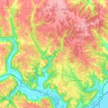
Nombre: Mapa topográfico Miller Township, altitud, relieve.
Altitud media: 224 m
Altitud mínima: 141 m
Altitud máxima: 290 m
Otros mapas topográficos
Haga clic en un mapa para ver su topografía, su altitud y su relieve.
Bright
United States > Indiana > Dearborn County
Bright, Miller Township, Dearborn County, Indiana, United States
Altitud media: 222 m
Mount Sinai
United States > Indiana > Dearborn County
Mount Sinai, Hogan Township, Dearborn County, Indiana, United States
Altitud media: 241 m
Greendale
United States > Indiana > Dearborn County > Greendale
Greendale, Lawrenceburg Township, Dearborn County, Indiana, United States
Altitud media: 168 m
Oldtown
United States > Indiana > Dearborn County > Lawrenceburg
Oldtown, Lawrenceburg, Lawrenceburg Township, Dearborn County, Indiana, 41080, United States
Altitud media: 156 m