
Mapa topográfico Green Valley
Mapa interactivo
Haga clic en el mapa para ver la altitud.
Acerca de este mapa
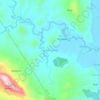
Nombre: Mapa topográfico Green Valley, altitud, relieve.
Altitud media: 81 m
Altitud mínima: 8 m
Altitud máxima: 386 m
Otros mapas topográficos
Haga clic en un mapa para ver su topografía, su altitud y su relieve.
Cagbuhangin
Philippines > Leyte > Ormoc
Cagbuhangin, Ormoc, 4th District, Leyte, Eastern Visayas, 6541, Philippines
Altitud media: 66 m
Lake Danao
Philippines > Leyte > Ormoc
Lake Danao, Ormoc, Leyte 4th District, Leyte, Eastern Visayas, 6541, Philippines
Altitud media: 729 m
Binahaan River
Philippines > Leyte > Ormoc
Binahaan River, Ormoc, Leyte 4th District, Leyte, Eastern Visayas, 6541, Philippines
Altitud media: 516 m
Malbasag River
Philippines > Leyte > Ormoc
Malbasag River, Ormoc, Leyte 4th District, Leyte, Eastern Visayas, 6541, Philippines
Altitud media: 200 m
Pagsangahan River
Philippines > Leyte > Ormoc
Pagsangahan River, Ormoc, Leyte 4th District, Leyte, Eastern Visayas, 6541, Philippines
Altitud media: 2 m
Anilao River
Philippines > Leyte > Ormoc
Anilao River, Ormoc, Leyte 4th District, Leyte, Eastern Visayas, 6541, Philippines
Altitud media: 80 m
Cambantog
Philippines > Leyte > Ormoc > Cambantog
Cambantog, Ormoc, Leyte 4th District, Leyte, Eastern Visayas, 6541, Philippines
Altitud media: 729 m
Ormoc
Philippines > Leyte > Ormoc
Ormoc, Leyte 4th District, Leyte, Eastern Visayas, 6541, Philippines
Altitud media: 201 m