
Mapa topográfico Bronx County
Mapa interactivo
Haga clic en el mapa para ver la altitud.
Acerca de este mapa
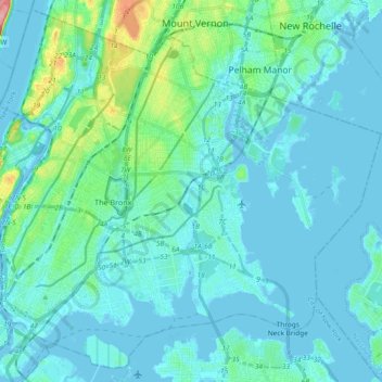
Nombre: Mapa topográfico Bronx County, altitud, relieve.
Lugar: Bronx County, New York, United States of America (40.78533 -73.93366 40.91618 -73.74806)
Altitud media: 21 m
Altitud mínima: -7 m
Altitud máxima: 139 m
The Bronx's highest elevation at 280 feet (85 m) is in the northwest corner, west of Van Cortlandt Park and in the Chapel Farm area near the Riverdale Country School. The opposite (southeastern) side of the Bronx has four large low peninsulas or "necks" of low-lying land that jut into the waters of the East River and were once salt marsh: Hunt's Point, Clason's Point, Screvin's Neck and Throggs Neck. Further up the coastline, Rodman's Neck lies between Pelham Bay Park in the northeast and City Island. The Bronx's irregular shoreline extends for 75 square miles (194 km2).
Otros mapas topográficos
Haga clic en un mapa para ver su topografía, su altitud y su relieve.
WCBS-AM (New York)
United States of America > New York > New York
WCBS-AM (New York), Terrace Street, City Island, New York, The Bronx, Bronx County, New York, 10464, United States of America
Altitud media: 1 m
Queens
United States of America > New York > New York
Queens, Queens County, New York, United States of America
Altitud media: 12 m
Brooklyn
United States of America > New York > New York
Brooklyn, Kings County, New York, United States of America
Altitud media: 10 m