
Mapa topográfico Utah
Mapa interactivo
Haga clic en el mapa para ver la altitud.
Acerca de este mapa
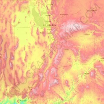
Nombre: Mapa topográfico Utah, altitud, relieve.
Lugar: Utah, United States (36.99781 -114.05285 42.00170 -109.04158)
Altitud media: 1.876 m
Altitud mínima: 789 m
Altitud máxima: 3.986 m
Western Utah is mostly arid desert with a basin and range topography. Small mountain ranges and rugged terrain punctuate the landscape. The Bonneville Salt Flats are an exception, being comparatively flat as a result of once forming the bed of ancient Lake Bonneville. Great Salt Lake, Utah Lake, Sevier Lake, and Rush Lake are all remnants of this ancient freshwater lake, which once covered most of the eastern Great Basin. West of the Great Salt Lake, stretching to the Nevada border, lies the arid Great Salt Lake Desert. One exception to this aridity is Snake Valley, which is (relatively) lush due to large springs and wetlands fed from groundwater derived from snow melt in the Snake Range, Deep Creek Range, and other tall mountains to the west of Snake Valley. Great Basin National Park is just over the Nevada state line in the southern Snake Range. One of western Utah's most impressive, but least visited attractions is Notch Peak, the tallest limestone cliff in North America, located west of Delta.
Otros mapas topográficos
Haga clic en un mapa para ver su topografía, su altitud y su relieve.
Houston
United States > Texas > Harris County
Houston, Harris County, Texas, United States
Altitud media: 25 m
Brooklyn
United States > New York > New York
Brooklyn, Kings County, New York, United States
Altitud media: 9 m
Spokane
United States > Washington > Spokane County
Spokane, Spokane County, Washington, United States
Altitud media: 655 m
College Station
United States > Texas > Brazos County
College Station, Brazos County, Texas, United States
Altitud media: 87 m
New Orleans
United States > Louisiana > Orleans Parish
New Orleans, Orleans Parish, Louisiana, United States
Altitud media: 1 m
Boulder
United States > Colorado > Boulder County
Boulder, Boulder County, Colorado, United States
Altitud media: 1.785 m
Fort Worth
United States > Texas > Tarrant County
Fort Worth, Tarrant County, Texas, United States
Altitud media: 212 m
Hillsborough County
Hillsborough County, Florida, United States
Altitud media: 20 m
Albuquerque
United States > New Mexico > Bernalillo County
Albuquerque, Bernalillo County, New Mexico, United States
Altitud media: 1.688 m
Corpus Christi
United States > Texas > Nueces County
Corpus Christi, Nueces County, Texas, United States
Altitud media: 8 m
New Hanover County
United States > North Carolina
New Hanover County, North Carolina, United States
Altitud media: 4 m
Lexington
United States > Kentucky > Lexington
Lexington, Fayette County, Kentucky, 40508, United States
Altitud media: 285 m
Madison
United States > Wisconsin > Dane County
Madison, Dane County, Wisconsin, United States
Altitud media: 284 m
Indianapolis
United States > Indiana > Indianapolis
Indianapolis, Marion County, Indiana, 46204, United States
Altitud media: 241 m
Coeur d'Alene
United States > Idaho > Kootenai County
Coeur d'Alene, Kootenai County, Idaho, United States
Altitud media: 719 m
Black Hills
United States > South Dakota > Pennington County
Black Hills, Pennington County, South Dakota, United States
Altitud media: 1.894 m
Greenwich
United States > Connecticut > Western Connecticut Planning Region
Greenwich, Western Connecticut Planning Region, Connecticut, United States
Altitud media: 57 m