
Mapa topográfico Old Stone Fort State Archaeological Park
Mapa interactivo
Haga clic en el mapa para ver la altitud.
Acerca de este mapa
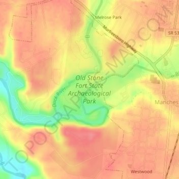
Nombre: Mapa topográfico Old Stone Fort State Archaeological Park, altitud, relieve.
Altitud media: 316 m
Altitud mínima: 268 m
Altitud máxima: 339 m
The Duck River system spills over a limestone-rich shelf of the western Cumberland Plateau known as the Highland Rim. As the Duck and Little Duck approach their convergence, they rapidly drop in elevation, and have cut relatively deep gorges around the peninsula upon which the ancient structure is located. Both gorges are highlighted by a series of substantial waterfalls and whitewater rapids. The natural waterpower in these two gorges attracted entrepreneurs and millwrights throughout the 19th century.
Otros mapas topográficos
Haga clic en un mapa para ver su topografía, su altitud y su relieve.
Glenview
United States > Tennessee > Coffee County > Manchester
Glenview, Manchester, Coffee County, Middle Tennessee, Tennessee, 37355, United States
Altitud media: 322 m
White Oaks
United States > Tennessee > Coffee County > Manchester
White Oaks, Manchester, Coffee County, Tennessee, 38505, United States
Altitud media: 325 m
Belmont
United States > Tennessee > Coffee County > Manchester
Belmont, Manchester, Coffee County, Middle Tennessee, Tennessee, United States
Altitud media: 320 m
Royal Oaks
United States > Tennessee > Coffee County > Manchester > Royal Oaks
Royal Oaks, Manchester, Coffee County, Tennessee, 38505, United States
Altitud media: 326 m
Westwood
United States > Tennessee > Coffee County > Manchester > Westwood
Westwood, Manchester, Coffee County, Tennessee, 37183:37355, United States
Altitud media: 322 m