
Haz una donación
Mapa topográfico Kamchatka Peninsula
Haga clic en el mapa para ver la altitud.
Haz una donación
Acerca de este mapa
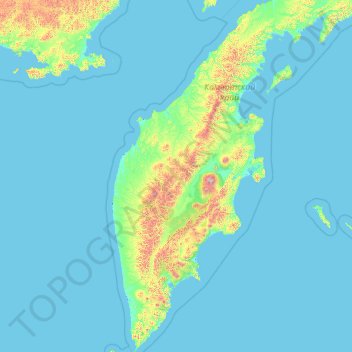
Nombre: Mapa topográfico Kamchatka Peninsula, altitud, relieve.
Lugar: Kamchatka Peninsula, Far Eastern Federal District, Russia (50.86520 155.55294 60.87091 164.34624)
Altitud media: 120 m
Altitud mínima: -3 m
Altitud máxima: 3.808 m
Haz una donación
Otros mapas topográficos
Haga clic en un mapa para ver su topografía, su altitud y su relieve.
Mount Elbrus (West Summit)
Russia > Karachay-Cherkessia > Karachayevsky District
As Elbrus is located in the Northern Hemisphere, the summer period takes place from June to mid-September, with an average of 50% of sunny days favorable to the ascent of the summit. However, the winds, dominated by westerly air masses, can turn violent and temperatures drop very quickly. Above 4000 meters…
Altitud media: 5.161 m
Haz una donación
Ural Mountains
Russia > Khanty-Mansiysk Autonomous Okrug – Ugra > Beryozovsky District
The Ural Mountains (/ˈjʊərəl/ YOOR-əl; Russian: Ура́льские го́ры, tr. Uralskiye gory, IPA: [ʊˈralʲskʲɪjə ˈɡorɨ]; Bashkir: Урал тауҙары) or simply the Urals, are a mountain range in Eurasia that runs north-south mostly through Russia, from the coast of the Arctic Ocean to…
Altitud media: 1.435 m
Sochi
Russia > Krasnodar Krai > Resort Town of Sochi (municipal formation)
Sochi has a humid subtropical climate (Köppen climate classification Cfa), at the lower elevations. Its average annual temperature is 18.9 °C (66.0 °F) during the day and 11.5 °C (52.7 °F) at night. In the coldest months—January and February—the average temperature is about 10 °C (50 °F) during the…
Altitud media: 148 m
Haz una donación
Siberia
Russia > Krasnoyarsk Krai > Boguchansky Rayon
Eastern and central Sakha comprises numerous north–south mountain ranges of various ages. These mountains extend up to almost 3,000 metres (9,800 ft), but above a few hundred metres they are almost completely devoid of vegetation. The Verkhoyansk Range was extensively glaciated in the Pleistocene, but the…
Altitud media: 346 m
Dzhugdzhur Mountains
Russia > Khabarovsk Krai > Ayano-Maysky Rayon
The coastal stretch of the range is populated by Japanese stone pine and Dahurian larch. Parts of the range occupied by the Okhotsk-Manchurian taiga ecoregion contain swathes of Jezo spruce up to elevations of 1,300 m.
Altitud media: 1.564 m
Haz una donación
Verkhoyansk
Russia > Sakha Republic > Verkhoyansky Ulus
In this area, temperature inversions consistently form in winter due to the extremely cold and dense air of the Siberian High pooling in deep hollows, so that temperatures increase rather than decrease with higher altitude. In Verkhoyansk it sometimes happens that the average minimum temperatures for January,…
Altitud media: 140 m
Haz una donación
Haz una donación
Haz una donación
Haz una donación
Haz una donación
Haz una donación
Kruzenshtern
Russia > Arkhangelsk Oblast > Novaya Zemlya Urban Okrug
The mountain was first put on the map in the 1820s by Arctic explorer Fyodor Litke (1797–1882) following his Novaya Zemlya explorations. It was named after Imperial Russian Navy Admiral Ivan Kruzenshtern (1770–1846). The mountain's name must have been known to Soviet topographers, but for undisclosed…
Altitud media: 1.046 m
Haz una donación
Mount Yamantau
Russia > Bashkortostan > Beloretsky District
Up to 1,000–1,100 m elevation, the mountain slope is covered with mixed forest, in some places with driftwood, occasional alpine meadows and rocky outcrops. Above 1,100 m elevation, there are no trees or bushes, and instead rock streams of various sizes, with grass, flowers and moss start to appear.
Altitud media: 1.334 m
Haz una donación
Haz una donación
Haz una donación
Haz una donación
озеро Коробейниково
Russia > Sverdlovsk Oblast > Тавдинский муниципальный округ > Азанка
Altitud media: 72 m
Haz una donación
Oymyakon
Russia > Sakha Republic > Oymyakonsky Ulus
With an extreme subarctic climate (Köppen climate classification Dfd, Trewartha climate classification Ecle), Oymyakon is known as one of the places considered the Northern Pole of Cold, the other being the town of Verkhoyansk, located 629 km (391 mi) away by air. The weather station is in a valley between…
Altitud media: 679 m
Haz una donación
Haz una donación
Mount Yamantau
Russia > Bashkortostan > Beloretsky District
Up to 1,000–1,100 m elevation, the mountain slope is covered with mixed forest, in some places with driftwood, occasional alpine meadows and rocky outcrops. Above 1,100 m elevation, there are no trees or bushes, and instead rock streams of various sizes, with grass, flowers and moss start to appear.
Altitud media: 1.334 m
Haz una donación
Haz una donación
Haz una donación
Haz una donación
Haz una donación
Haz una donación
Tunguska event
Russia > Krasnoyarsk Krai > Evenkiysky Rayon
The Tunguska event was a large explosion of between 3 and 50 megatons that occurred near the Podkamennaya Tunguska River in Yeniseysk Governorate (now Krasnoyarsk Krai), Russia, on the morning of 30 June 1908. The explosion over the sparsely populated East Siberian taiga felled a large number of trees, over an…
Altitud media: 333 m
Haz una donación
Haz una donación