
Haz una donación
Mapa topográfico Kennesaw
Haga clic en el mapa para ver la altitud.
Haz una donación
Kennesaw
Kennesaw is located in northwestern Cobb County, bordered by the city of Acworth to the northwest. Kennesaw Mountain is located southeast of the city limits in the battlefield park. Its summit is the highest point in the Atlanta metro area, at an elevation of 1,808 feet (551 m) above sea level. The city was renamed for the mountain.
Haz una donación
Acerca de este mapa
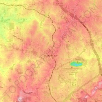
Nombre: Mapa topográfico Kennesaw, altitud, relieve.
Lugar: Kennesaw, Cobb County, Georgia, United States (33.98696 -84.65002 34.06690 -84.58092)
Altitud media: 317 m
Altitud mínima: 167 m
Altitud máxima: 393 m
Haz una donación
Otros mapas topográficos
Haga clic en un mapa para ver su topografía, su altitud y su relieve.
Vinings
United States > Georgia > Cobb County
Vinings features a varied topography characterized by rolling hills and lush, wooded areas that provide a picturesque backdrop to the community. The area is nestled alongside the Chattahoochee River, which contributes to the gentle slopes and valleys that define the landscape. Elevations in Vinings typically…
Altitud media: 281 m
Haz una donación
Haz una donación
Kennesaw
United States > Georgia > Cobb County > Kennesaw
Kennesaw is located in northwestern Cobb County, bordered by the city of Acworth to the northwest. Kennesaw Mountain is located southeast of the city limits in the battlefield park. Its summit is the highest point in the Atlanta metro area, at an elevation of 1,808 feet (551 m) above sea level. The city was…
Altitud media: 318 m