
Mapa topográfico Pantelleria
Mapa interactivo
Haga clic en el mapa para ver la altitud.
Acerca de este mapa
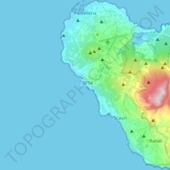
Nombre: Mapa topográfico Pantelleria, altitud, relieve.
Lugar: Pantelleria, Trapani, Sicily, 91017, Italy (36.73438 11.92586 36.83939 12.05684)
Altitud media: 83 m
Altitud mínima: 0 m
Altitud máxima: 824 m
Pantelleria has a subtropical Mediterranean climate (Köppen: Csa) characterized by very warm to hot, almost rainless and humid summers, very mild and frost-free winters, a powerful seasonal lag and a small diurnal temperature range. The constant sea breezes, moderate the daytime summer temperatures. Coastal Pantelleria (along with Lampedusa and coastal Malta) is one of the very few areas along the Mediterranean Sea coast, which have never recorded frost. Below freezing temperatures and snow only and sporadically occur at Montagna Grande and at higher elevations on the island. Despite the very dry summers and the fairly low annual precipitation, the dry season is noticeably shorter at four months, and the rainy season lasts at least for eight months.
Otros mapas topográficos
Haga clic en un mapa para ver su topografía, su altitud y su relieve.
Alcamo Marina
Italy > Sicily > Trapani > Alcamo
Alcamo Marina, Alcamo, Trapani, Sicily, 91011, Italy
Altitud media: 46 m
Borgata Costiera
Italy > Sicily > Trapani > Mazara del Vallo
Borgata Costiera, Mazara del Vallo, Trapani, Sicily, 91026, Italy
Altitud media: 95 m
Mazara del Vallo
Mazara del Vallo, Trapani, Sicily, 91026, Italy
Altitud media: 49 m