
Mapa topográfico Bellevue
Mapa interactivo
Haga clic en el mapa para ver la altitud.
Acerca de este mapa
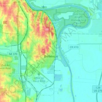
Nombre: Mapa topográfico Bellevue, altitud, relieve.
Lugar: Bellevue, Sarpy County, Nebraska, United States (41.09278 -96.00926 41.19110 -95.87084)
Altitud media: 310 m
Altitud mínima: 288 m
Altitud máxima: 385 m
Bellevue is located at an elevation of 1159 ft (353 m). According to the United States Census Bureau, the city has a total area of 16.02 square miles (41.49 km2), of which 15.85 square miles (41.05 km2) is land and 0.17 square miles (0.44 km2) is water. It is bounded on the east by the Missouri River.
Otros mapas topográficos
Haga clic en un mapa para ver su topografía, su altitud y su relieve.
Springfield
United States > Nebraska > Sarpy County
Springfield, Sarpy County, Nebraska, 68059, United States
Altitud media: 344 m
Sarpy County
United States > Nebraska > Sarpy County
Sarpy County, Nebraska, United States
Altitud media: 343 m