
Haz una donación
Mapa topográfico Cap-Chat
Haga clic en el mapa para ver la altitud.
Haz una donación
Acerca de este mapa
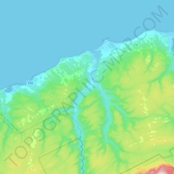
Nombre: Mapa topográfico Cap-Chat, altitud, relieve.
Altitud media: 166 m
Altitud mínima: -4 m
Altitud máxima: 1.023 m
Haz una donación
Otros mapas topográficos
Haga clic en un mapa para ver su topografía, su altitud y su relieve.
Notre Dame Mountains
Canada > Quebec > La Haute-Gaspésie > Mont-Albert
The Chic-Choc Mountains are one of the primary subranges of the Notre Dame Mountains. They are located in the northeastern part of the Gaspé Peninsula and are home to the tallest mountain in the range, Mont Jacques-Cartier, with an elevation of 1,268 m (4,160 ft). The other major subsection of the Notre Dame…
Altitud media: 1.128 m
Rivière-la-Madeleine
Canada > Quebec > La Haute-Gaspésie > Sainte-Madeleine-de-la-Rivière-Madeleine
Altitud media: 46 m
Madeleine-Centre
Canada > Quebec > La Haute-Gaspésie > Sainte-Madeleine-de-la-Rivière-Madeleine
Altitud media: 72 m
Haz una donación
Haz una donación